
1 Rural Train Station - Canada
2
3

4
5
6
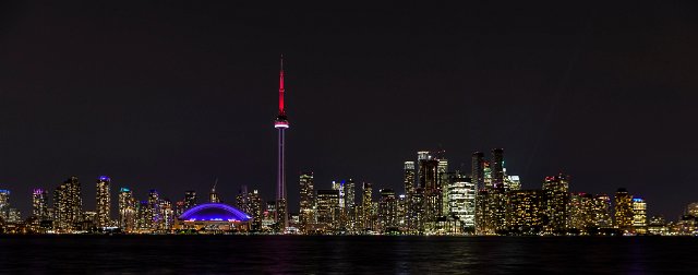
7 Toronto Skyline
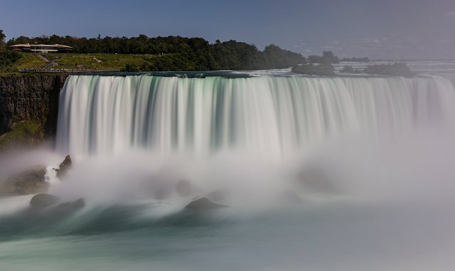
8 Niagara Falls (/naɪˈæɡrə/) is the collective name for three waterfalls that straddle the international border between Canada and the United States; more specifically, between the province of Ontario and the state of New York. They form the southern end of the Niagara Gorge.
From largest to smallest, the three waterfalls are the Horseshoe Falls, the American Falls and the Bridal Veil Falls. The Horseshoe Falls lies on the border of the United States and Canada with the American Falls entirely on the United States' side, separated by Goat Island. The smaller Bridal Veil Falls are also on the United States' side, separated from the other waterfalls by Luna Island. The international boundary line was originally drawn through Horseshoe Falls in 1819, but the boundary has long been in dispute due to natural erosion and construction.
Located on the Niagara River, which drains Lake Erie into Lake Ontario, the combined falls form the highest flow rate of any waterfall in the world that has a vertical drop of more than 165 feet (50 m). Horseshoe Falls is the most powerful waterfall in North America, as measured by flow rate. The falls are 17 miles (27 km) north-northwest of Buffalo, New York, and 75 miles (121 km) south-southeast of Toronto, between the twin cities of Niagara Falls, Ontario, and Niagara Falls, New York.
Niagara Falls was formed when glaciers receded at the end of the Wisconsin glaciation (the last ice age), and water from the newly formed Great Lakes carved a path through the Niagara Escarpment en route to the Atlantic Ocean. While not exceptionally high, Niagara Falls is very wide. More than six million cubic feet (168,000 m3) of water falls over the crest line every minute in high flow,[4] and almost four million cubic feet (110,000 m3) on average.[citation needed]
Niagara Falls is famed both for its beauty and as a valuable source of hydroelectric power. Balancing recreational, commercial, and industrial uses has been a challenge for the stewards of the falls since the 19th century.
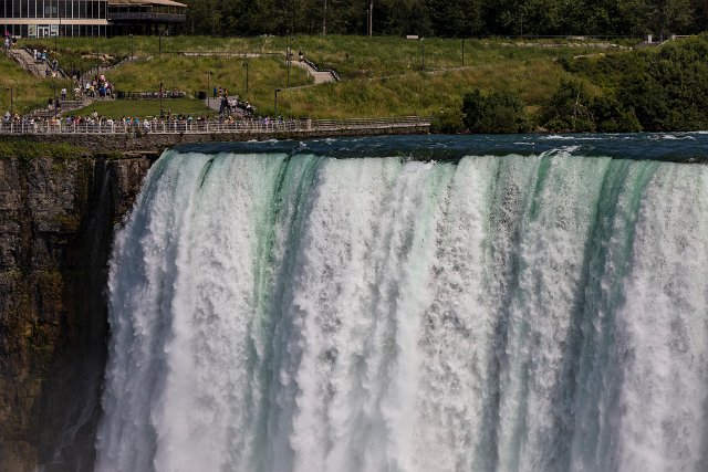
9 Niagara Falls (/naɪˈæɡrə/) is the collective name for three waterfalls that straddle the international border between Canada and the United States; more specifically, between the province of Ontario and the state of New York. They form the southern end of the Niagara Gorge.
From largest to smallest, the three waterfalls are the Horseshoe Falls, the American Falls and the Bridal Veil Falls. The Horseshoe Falls lies on the border of the United States and Canada with the American Falls entirely on the United States' side, separated by Goat Island. The smaller Bridal Veil Falls are also on the United States' side, separated from the other waterfalls by Luna Island. The international boundary line was originally drawn through Horseshoe Falls in 1819, but the boundary has long been in dispute due to natural erosion and construction.
Located on the Niagara River, which drains Lake Erie into Lake Ontario, the combined falls form the highest flow rate of any waterfall in the world that has a vertical drop of more than 165 feet (50 m). Horseshoe Falls is the most powerful waterfall in North America, as measured by flow rate. The falls are 17 miles (27 km) north-northwest of Buffalo, New York, and 75 miles (121 km) south-southeast of Toronto, between the twin cities of Niagara Falls, Ontario, and Niagara Falls, New York.
Niagara Falls was formed when glaciers receded at the end of the Wisconsin glaciation (the last ice age), and water from the newly formed Great Lakes carved a path through the Niagara Escarpment en route to the Atlantic Ocean. While not exceptionally high, Niagara Falls is very wide. More than six million cubic feet (168,000 m3) of water falls over the crest line every minute in high flow,[4] and almost four million cubic feet (110,000 m3) on average.[citation needed]
Niagara Falls is famed both for its beauty and as a valuable source of hydroelectric power. Balancing recreational, commercial, and industrial uses has been a challenge for the stewards of the falls since the 19th century.
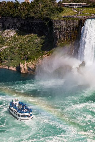
10 Niagara Falls (/naɪˈæɡrə/) is the collective name for three waterfalls that straddle the international border between Canada and the United States; more specifically, between the province of Ontario and the state of New York. They form the southern end of the Niagara Gorge.
From largest to smallest, the three waterfalls are the Horseshoe Falls, the American Falls and the Bridal Veil Falls. The Horseshoe Falls lies on the border of the United States and Canada with the American Falls entirely on the United States' side, separated by Goat Island. The smaller Bridal Veil Falls are also on the United States' side, separated from the other waterfalls by Luna Island. The international boundary line was originally drawn through Horseshoe Falls in 1819, but the boundary has long been in dispute due to natural erosion and construction.
Located on the Niagara River, which drains Lake Erie into Lake Ontario, the combined falls form the highest flow rate of any waterfall in the world that has a vertical drop of more than 165 feet (50 m). Horseshoe Falls is the most powerful waterfall in North America, as measured by flow rate. The falls are 17 miles (27 km) north-northwest of Buffalo, New York, and 75 miles (121 km) south-southeast of Toronto, between the twin cities of Niagara Falls, Ontario, and Niagara Falls, New York.
Niagara Falls was formed when glaciers receded at the end of the Wisconsin glaciation (the last ice age), and water from the newly formed Great Lakes carved a path through the Niagara Escarpment en route to the Atlantic Ocean. While not exceptionally high, Niagara Falls is very wide. More than six million cubic feet (168,000 m3) of water falls over the crest line every minute in high flow,[4] and almost four million cubic feet (110,000 m3) on average.[citation needed]
Niagara Falls is famed both for its beauty and as a valuable source of hydroelectric power. Balancing recreational, commercial, and industrial uses has been a challenge for the stewards of the falls since the 19th century.


Canada